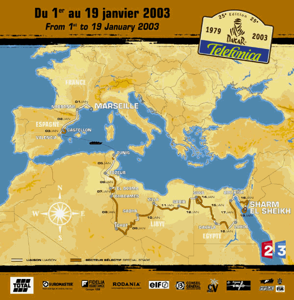
25th Paris-Dakar Rally 2003
Details of the competition
17 stages
3 in Europe
3 in Tunisia
5 in Libya
6 in Egypt
A total of 8552 Km, including 5216 km of special stages and 3306 km of liaison.
In Africa
7 642 km in total, including 5205 km of specials
7.797 km for the assistance
1 rest day: Siwa
1 loop stage: Siwa - Siwa
1 marathon stage without assistance: Ghadamès - Ghat
2 stages without GPS: Silla - Zarir and Luxor - Abu Rish
Longest stage: Abu Rish - Sharm El Sheikh (828 km)
Shortest stage: Sharm El Sheikh - Sharm El Sheikh (56 km)
Longest special stage: Ghadames - Ghat (584 km)
Shortest special stage: Tunis - Tozeur (25 km)
Europe
Scrutineering
Monday 30th and Tuesday 31st December 2002
Details of the start:
30th and 31st of December 2002: administrative and technical scrutineering in the Parc Chanot in the Bouches du Rhône region (Marseille). Free entry.
Parc Fermé, situated in the Parc Chanot from the 30th of December 2002 to the 1st of January 2003.
Start: 1st of January 2003. The podium is set up in the Parc Chanot.
Marseille is the county town of the Bouches du Rhône region. Second largest town in France, Marseille is the first French commercial and passenger port. Twenty five centuries of history make Marseille the most ancient of the large French towns.
STAGE 1: MARSEILLE - NARBONNE
Wednesday 1st January 2003
Prologue: 1 km - Liaison: 290 km - Total: 291 km
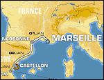
Route within Parc Chanot on 2 parallel tracks. The night prologue is an event in itself, where people and machines give of their best on a track created specially for the occasion. An unmissable, fun evening. Free access for all. At the end, competitors go on a link towards Narbonne. Two check-points are organised: at Salon de Provence and Nimes where a hot meal is served for competitors in the arenas. The Rally first came through Narbonne in 1998.
The entire caravan stops at Narbonne, a delightful city in the department of Aude, surrounded by the remains of a rich past. Colonised by the Romans in 118 BC, the old town, flourishing port and business area, were extremely prosperous throughout Roman times. An important centre for communications between France and Spain, nowadays Narbonne is a city of business and tourism.
STAGE 2: NARBONNE - CASTELLÓN
Thursday 2nd January 2003
Liaison: 21 km - Special: 43 km - Liaison: 510 km - Total : 574 km
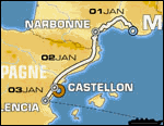
After a repair night, competitors go on a link towards Castellón (Comunitat Valenciana), located 60 km North of Valencia, on the East coast of Spain. A funny party will be organised. The Rally first came through Castellón in 2001.
The rally first went to Château Lastours in 1994.
Castellón, a city with a population of about 150,000, offers magnificent tourist ameni-ties, a grand 14 km beach, modern sports facilities and an ideal temperature for enjoying unforgettable holidays that encourage the most demanding tourists to come back again. Castellón is the most northerly of the three provinces in Comunitat Valenciana, the second most mountainous province in Spain with the Pic de Penyagolosa reaching 1,812 metres (5,940 feet).
STAGE 3: CASTELLÓN - VALENCIA
Friday 3rd January 2003
Liaison: 5 km - Special: 8 km - Liaison: 82 km - Total: 95 km
The special stage is around Castellón. The finish is laid out on the beach. At the end of the special stage, competitors go to the port of Valencia for boarding. The ship sets sail at night, but before leaving for Africa, a giant paella is organised for everyone by the Comunitat Valenciana.
Capital of the independent community of Valencia located 3 km from the Mediterranean, Valencia is the country's third largest town (population 749,361).
Valencia has a large agricultural market, at the centre of a rich huerta (citrus, rice, fruit and vegetables, wine) and maintains its place as an important industrial intersection served by the port of El Grao (7.8 Mt of freight and 0.4 million passengers). Curiosities: Numerous churches and monuments from the 13th to the 18th centuries.
TRANSFER BY SEA
Saturday 4th January 2003
Competitors are on board ship for one day and two nights. Entertainment is organised and there is a general briefing. A first break before setting about serious matters in Africa.
STAGE 4: TUNIS - TOZEUR
Sunday 5th January 2003
Liaison: 89 km - Special stage: 25 km - Liaison: 349 km - Total: 463 km
Parallel itinerary for support crews: 450 km
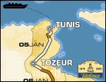
After the crossing, competitors disembark at the port of Tunis. The first part of the special stage is marked out on steep, twisting tracks, among hills and pine forests. The track has very irregular curves. Gradually, it becomes less twis-ty, wider and dusty, amidst valleys with a succession of fields. It allows plenty of scope for driving and is the shortest of the special stages in this 25th edition. A special stage for getting into shape, very good, finishing with a link up to the gateway to the desert.
Tozeur is the one of the most famous oases in the world, irrigated by 200 springs. It is home to a magnificent palm grove of more than 1,000 hectares (2,500 acres) that has over 400,000 date palms. Tozeur is the ultimate oasis town and continues a strong cultural tradition.
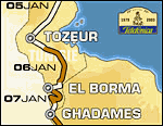
STAGE 5: TOZEUR - EL BORMA
Monday 6th January 2003
Liaison: 133 km - Special stage: 285 km - Liaison: 76 km - Total: 494 km
Parallel itinerary for support crews: 578 km
Competitors get down to the real meat: the terrain becomes sandy and the first crossings appear, as well as many changes in direction.
At the start of the special stage, the track is fast with alternating stretches of stones and sand. Then, as the kilometres pass, bit by bit it reaches low dunes and tongues of sand, with alternating fast and twisting sections.
First off-road and first crossings!
In the middle of the special stage, tracks are rolling, stony, fast, with undulations and "jumps". The way snakes between the hills and navigation is more difficult: numerous parallel tracks with not many landmarks! Fast end special stage.
Located in the far south of Tunisia, about 800 km south of Tunis, hidden in the great erg of the East Sahara, El Borma is the top oil production area in Tunisia and one of the biggest in the Sahara. The word "borma" in Tunisian means "razor teeth", poetic imagery for the keen edged El Borma dunes.
STAGE 6: EL BORMA - GHADAMES
Tuesday 7th January 2003
Liaison: 13 km - Special stage: 228 km - Liaison: 37 km - Total: 278 km
Parallel itinerary for support crews: 298 km

First real big stage for competitors and in particular for new entrants in the Telefónica - Dakar 2003, who have the opportunity to demonstrate the full extent of their prowess through this special stage, laid out totally off road. In the programme: numerous crossings of Ergs and successive
belts of dunes. Keep an eye on the clock! There's all it needs to lose a lot of time and placings can be completely rever-sed. A stage that should benefit the toughest, most skilled drivers, whether beginners or professionals!
Within the confines of the Hamada al Hamrah or "red plateau", an immense plateau that stretches to the south of Djebel Nafusah, built on an oasis (Fezzan), Ghadames, also known as "the pearl of the desert", is one of the oldest pre-Saharan towns. Beyond its palm groves, lie the first dunes of the great eastern erg. A fortified oasis, whose shaded streets meander between houses made of mud bricks, Ghadames has been classified a world heritage site by UNESCO.
Libya
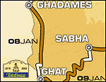
STAGE 7: GHADAMES - GHAT
Wednesday 8th January 2003
Liaison: 5 km - Special stage: 584 km - Liaison: 102 km - Total: 691 km
Parallel itinerary for support crews: 837 km
First marathon stage. The assistance vehicles, (except those in race) are not at the Ghat camp. They go directly to Sabha. One of the best stages of this Telefónica - Dakar 2003 that marks the entry into Libya! Tip-top physical condition and faultlessly prepa-red vehicles are essential.
The track, fast yet varied over the first 300 kilometres, takes competitors to the entrance of the Awbari erg, already crossed during the 1989 edition: 50 kilometres of giant dunes with magnificent shapes. It's a question of finding the right way between the massive ergs - every time. The track then continues through superb landscapes: canyons and other great expanses of sand, with alternately every type of difficulties that can be met with on a rally like the Dakar. This is the longest special stage in the rally.
The Ghat oasis, located at the crossroads of the routes, has the greatest area of pastureland in the region. The origin of its name comes from "arata" ("lizard" in Tamasheq). It is dominated by Mount Koukemen, topped by Ghat fort. Ghat was founded in the 12th century by the Berbers of the Ihadjenen tribe. It was from its fort that Captain Gardel took to the road in 1915 and whose adventure was translated in "Fort Saganne".
STAGE 8: GHAT - SABHA
Thursday 9th January 2003
Liaison: 49 km - Special stage: 497 km - Liaison: 181 km - Total: 727 km

The best of the special stages in this Telefónica - Dakar 2003 and probably one of the most difficult in the history of the event: 500 km of fabulous country, endless crossings and extremely varied terrain. On lea-ving Ghat, the track goes down due south towards Algeria before coming back up through the Akakus massif, consisting of giant dunes and chiselled rocks. Once this 100 km is over, competitors drive off road to the famous Murzuk Erg, known for its great waves of uncrossable sand, last difficulty on the special stage.
The Tadrart Akakus region is classified by UNESCO as a World Heritage site, in recognition of the exceptional richness of its rock carvings and paintings. The Akakus is a huge, asymmetri-cal range that looks like a thick slab of sandstone, higher at the west side, where it dominates the Ghat valley, and then gently slopes away to the east.
Sabha is located in Libyan Sahara, at the gates of the Fezzan. A town with a population of 36,000, it is at the heart of a region marked by pre-history: it has the largest number of rock car-vings and paintings in the world.
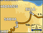
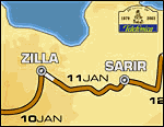
STAGE 9: SABHA - ZILLA
Friday 10th January 2003
Liaison: 6 km - Special stage: 567 km - Liaison: 12 km - Total: 585 km
Parallel itinerary for support crews: 506 km
Every day spent in Libya brings strong feelings and unique landscapes. This stage is part of the pattern. After the sand crests of the Murzuk, a place of rolling plateaus that span the first 300 kilometres of the special stage, next come mountains with the volcanic Al Haruj Massif. A mass of little tracks with changes in direction every 300 metres, where competitors just must not lose north. Navigation here is tough because there are few reliable landmarks. In this region, volcano buffs find more than enough to satisfy their curiosity, and although accessing the rims of craters makes vehicles' tyres and shock absorbers suffer, the effort is rewarded. Imagine an environment of black rocks, sometimes, a few kilometres from one another, revealing volcanic cones with the bottoms of their craters holding light-coloured sand.
Zilla, an oil area, is located on the El-Haroudj el-Aswad or "black haruj" chain of mountains, occupying the centre of the country, its highest volcanic peak reaching 1,200 metres (3,900 feet). Like all Libyan Sahara, the landscape is one of infinite stones and sand, a world of plains and plateaus (hamadas), often scattered with stones (regs and sérirs), sometimes covered with massive dunes (ergs).
STAGE 10: ZILLA - SARIR
Saturday 11th January 2003
Liaison: 31 km - Special stage: 521 km - Liaison: 2 km - Total: 554 km
Parallel itinerary for support crews: 740 km
The 10th stage is a transition stage that allows the rally caravan to get its breath back! Competitors drive over 130 km of sandy tracks, then come to an off-road area until they reach Sarir. They pass through the middle of a "heap of sand" over a distance of 30 km. To spice up the day, this stage is the first to take place "without GPS", and co-drivers are the stars of the day.
Sarir is located at the entry to the Libyc desert, which includes Egypt and Libya. This desert is home to the Great Sand Sea, gigantesque mass of sand the length of the chain of oases (Al Khofra oasis). This is the most arid region in the Sahara, a huge area stretching over an area approximately 200 km wide and 600 km long (125 by 375 miles). Sarir is the most important oil site in Libya, but this is also the region that produces water that heads north via the world's biggest aqueduct.
STAGE 11: SARIR - SIWA
Sunday 12th January 2003
Liaison: 1 km - Special stage: 438 km - Liaison: 147 km - Total: 586 km
Parallel itinerary for support crews: 735 km
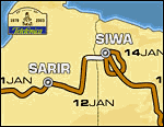
Great viewing guaranteed with this special stage marked out exclusively off-road! And what country: ergs ad infinitum; dunes that can tower up to 100 metres high. The difficulty is that you absolutely must keep the right course, when going over dunes. But the sand overall is good and a few descents turn out to be difficult. A tip: the shortest route is not always the quickest! At the end of the 438 kilometre special stage, competitors leave Libya. Arrival in Egypt and first camp at Siwa, a magnificent oasis, cradle of the Berber civilisation.
Egypt
REST DAY: SIWA
Monday 13th January 2003
Who could dream of a more beautiful place for a rest day than at the magnificent, thousand year-old city of Siwa. An oasis paradise in the western desert, Siwa is 600 kilometres from Cairo, south-west of the port town of Marsa al-Matruh and only about 25 km from the Libyan border. It was known in olden times for the oracle of Ammon, who Alexander the Great came to consult. It is Egypt's most secret oasis. There are 1,600 water sources there, hills the colour of gold, date palms and expanses of olive trees. This oasis, far from being an island lost in the desert, is linked to the big cities by major routes that have probably been used since the most ancient of times.
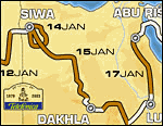
STAGE 12: SIWA - SIWA
Tuesday 14th January 2003
Liaison: 57 km - Special stage: 341 km - Liaison: 47 km - Total: 445 km
Parallel itinerary for support crews: 55 km
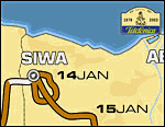
Start-up stage, in a loop, marked out to the south of the oasis, off-road, through the highest dunes in Egypt. You can count on excitement going down them. Posts mark the route. Support vehicles can enjoy the spectacle because they do not have to stay in camp: a support crew point is accessible half way round, right in the middle of the dunes. The finish for the special stage is judged near to this point, so much so that all fans who have come especially to Siwa because of the rest day can experience the 12th stage in full.
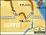
STAGE 13: SIWA - DAKHLA
Wednesday 15th January 2003
Liaison: 47 km - Special stage: 569 km - Liaison: 41 km - Total: 657 km
Parallel itinerary for support crews: 920 km
One of the high spots of this Telefónica -Dakar: the complete crossing of the "Great Sand Sea" for the first time. An ocean of dunes where nobody dares go: the "cathedral" dunes. Some of them are over 100 m.
The organisation has decided to mark some of the summits in order to indicate the places to cross them. The second part of the stage crosses the "White Desert". The winding track snakes between giant limestone mushrooms, typical of the region. The special stage ends by crossing a magnificent pass between the canyons. The descent of the cliff takes competitors to Dakhla oasis.
Dakhla is an oasis located between Til Qasr and Mut in the Western Desert, on the road linking Cairo to El-Kharga. From Siwa to Kharga, many oases stretch from North to South, including five large ones: Baharia, Farafra, Siwa, Dakhla and Kharga. True islands of greenery and life in the midst of the desert, they are all stops on the ancient caravan routes. In this extreme western part of the Sahara, the last dunes of the great Sand Sea plunge into the Farafra depression and extend as far as Dakhla, then on to the Sudan.
STAGE 14: DAKHLA - LUXOR
Thursday 16th January 2003
Liaison: 53 km - Special stage: 274 km - Liaison: 375 km - Total: 702 km
Parallel itinerary for support crews: 542 km
The day's special stage is laid out on a network of forgotten tracks, used in the times of the Pharaohs by camel caravans to link with Sudan.
The start of the special stage is marked by uphill bends, of hill-climb type, over 5 kilo-metres, taking competitors to a camel track. The track then disappears to give way to a very winding "trail", in rocky mountains. The only landmarks are hundred year-old cairns. Navigating, way off-road,
you have to find the right valley to get to the pass in order to go down the cliff. A kilometre long, the descent down a tongue of sand is the high point of the day. Take the time to admire what is around you such as the Temple of Karnack.
An Upper Egypt town, located 750 km south of Cairo on the right bank of the Nile, Luxor (from the Arab el-Qsour, the castles) is built on the site of old Thebes, named Ouaset by the Egyptians. Todays Luxor has become the tourist centre for Egyptian antiquities.
In ancient Egypt, the "Thebes of a hundred doors" was on the east bank of the Nile and occupied the land between the present day villages of Luxor and Karnack, 4 km away. Two archaeological sites are on this side of the river: the Karnack temples, to the north, are of striking size and splendour; the Luxor temple is remarkable because of its elegance.
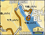
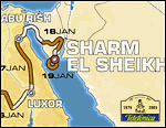
STAGE 15: LUXOR - ABU RISH
Friday 17th January 2003
Liaison: 75 km - Special stage: 477 km - Liaison: 24 km - Total: 576 km
Parallel itinerary for support crews: 632 km
Stage without GPS!
It is laid out on a well marked track, fairly rolling with alternating sections of sand and gravel. Numerous changes in direction are on the programme and care is vital so as not to take the wrong track. The special stage is especially testing for drivers with a definite advantage for drivers from the world of traditional and endurance rallying.
Abu Rish, an immense area of desert, is situated on a stony plateau between the Nile valley and the Suez Canal. The camp is set up near to the airport.
STAGE 16: ABU RISH - SHARM EL SHEIKH
Saturday 18th January 2003
Liaison: 413 km - Special stage: 365 km - Liaison: 50 km - Total: 828 km
Parallel itinerary for support crews: 634 km
The last stage before breathing the sweet scent of victory! The longest in this 25th edition. Set out at dawn, from the camp, to get to the start of the special stage. The last long special stage of this 25th edition marked out in the Sinai massif. It alternates driving in magnificent green valleys and stretches of difficult, rocky, narrow cols. A special stage at the end of which overall positions can still change.
The biggest seaside resort in Sinai, Sharm-el-Sheikh has grown amazingly in just a few years. Near to the Ras Mohammed National Park, it primarily developed on Naama Bay, which has become the tourist centre of the town with a concentration of hotels, restaurants, bars, shops, and diving centres.
Blessed with an extraordinary climate throughout the year, swimming in the clear water is very much enjoyed by all scuba diving enthusiasts.
STAGE 17 : SHARM EL SHEIKH - SHARM EL SHEIKH
Sunday 19th January 2003
Liaison: 13 km - Special stage: 34 km - Liaison: 9 km - Total : 56 km
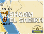
The last special of this 25th edition will take place near to the Sharm El Sheikh hotel facilities. A "show" special accessible to all spectators.
The other novelty of this final festive day : prize-giving will take place on the podium, following the finish of the special.